E SMITH
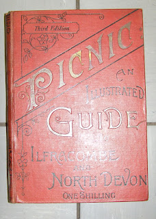
The Picnic guide to Ilfracombe and neighbourhood was published in the late 1880s by E Smith & Co. of Bristol with a text attributed to W H Turner of Bristol. A second edition, Picnic: an illustrated guide to Ilfracombe and North Devon, (dated 1890) has been seen with no maps, but the third edition has a total of three maps. In addition to the two maps described below, a further map – Map of the Bristol Channel - was included[1].

Smith, E 1a
Size: 380 x 500 mm. No scale.MAP OF Ilfracombe SHOWING ROADS, STREETS, TERRACES, CHURCHES, HOTELS, VILLAS ETC. (De in rectangle). Imprint: [PUBLISHED WITH “PICNIC GUIDE” BY E SMITH & Co, BRISTOL] (EeOS) and REGISTERED (AeOS).
Description: Stretches from Holy Trinity Church (Ae) to the Promenade Pier (Ea). Water areas coloured light green as is title panel.

Smith, E 1b
Size: 175 x 475 mm. Scale of (5 = 47 mm) miles.
Map of the COAST OF NORTH DEVON. (Ae). No imprint or signature.
Description: Stretches from Hartland Quay (Ad) to Porlock (Eb). Although key is for roads, only coach roads are shown. Steamer destinations are also illustrated. Water area coloured light green.
Both maps found in:
1. 1891 Picnic: an illustrated guide to Ilfracombe and North Devon, with notes on Lynmouth, Clovelly, Lundy and adjacent regions, including a description of the journey by steamer from Bristol to Ilfracombe / by W.H.Turner.. - Third Edition Bristol. E Smith. 1891. BL, DevA.

RETURN to Catalogue of Maps
NOTES:
[1] This map is 103 x 195 mm has no scale and has an imprint: Published by E Smith, Stone Bridge. It also shows southern Wales with Swansea, Cardiff and Newport. All illustrations courtesy of Devon Archives and Heritage Centre.
[1] This map is 103 x 195 mm has no scale and has an imprint: Published by E Smith, Stone Bridge. It also shows southern Wales with Swansea, Cardiff and Newport. All illustrations courtesy of Devon Archives and Heritage Centre.


No comments:
Post a Comment